The Business Value of Moving to the Utility Network is in Data Analytics
Replicating everything you already have in your current GIS in the Utility Network is the easiest thing to do. However, simply lifting & shifting what you already have in a new, state of the art platform leaves enormous business value on the table. The real business value of the Utility Network lies in solving a new set of business challenges at the utility. Solving these challenges requires looking beyond what has been done in the past to everything that is possible with the power of the UN. As the business drivers for GIS have evolved, so must the system itself.

Your move to the UN provides an opportunity to move beyond traditional GIS capabilities to advanced data analytics. The modern utility needs actionable information, at a pace that matches demand, in a format the is accessible and easy to understand. The UN is the perfect platform for performing complex analyses that translate to fast, effective operational decisions.
Why the Utility Network is the Ideal Framework for Integration & Advanced Analytics
“We believe we have all the data. We just don’t have it organized.” Sound familiar? The majority of utilities today are not able to effectively bring the full power of the data produced by their operational systems to bear in solving problems and planning and managing network operations. Operational systems are creating silos of data because there is not enough communication between systems. Every utility has some level of integration between some of the systems – but not between all the systems, and a great deal of detail behind the assets is left out of the equation.

The Utility Network can not only be a framework for integration across the systems, but also a framework for advanced analytics itself. To get there requires thinking a little differently. It requires opening up the possibility of bringing a new level of detail to GIS data. Instead of thinking “Why GIS?” we need to think, “Why not GIS?” Past technology constraints or biases about what data does or does not “belong” in GIS should not cloud our thinking about what is possible with the newest evolution of technology.
The Utility Network is scienced-based technology capable of performing powerful calculations and analyses. Here’s why the Utility Network is the right framework for both integration and advanced analytics.
- It provides the where
- It provides the connected model
- It provides situational awareness
- It’s a science-based system
- It’s visual
- It’s multi-discipline
- It’s depended upon
How to Move Beyond Mapping to Advanced Analytics with the Utility Network
The Utility Network presents the opportunity to create a GIS that is built for the future. Simply porting your Geometric Network over to the Utility Network risks leaving enormous value on the table. Moving beyond mapping to advanced analytics will increase the value of your system.
Here’s how to get started with creating a vision for a GIS that moves beyond traditional capabilities.
- Change the way you think about GIS. Think beyond mapping. Think without limits. Remove the guardrails and re-evaluate how GIS can better serve engineering, operations, and customer service. Anything is possible with the technology. Look at what can be done going forward instead of looking at how things have been done in the past.
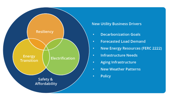
- Make GIS a part of the solution. Utilities are facing complex challenges related to energy transition, resiliency, and electrification. Think about how GIS can play a bigger role in overcoming hurdles to operational efficiency, reliability and safety.
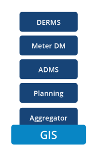
- Look to make other systems better and more timely. Work across the organization to evaluate how GIS can make ADMS and other operational systems better. What information or analytics can GIS add to the equation? What are the best update intervals for connected systems?
- Exercise analytical capabilities. Fully expose the analytical capabilities of GIS. There is no better system for visualizing scenarios and surfacing problems and solutions.
The following tactical steps will help position you for success:
- Establish data governance. As data flow across systems becomes more fluid, the importance of data governance is critical. Establish rules and procedures for how data is collected, stored, processed, and used across systems.
- Re-engineer, document, and enforce your workflows. It is critical to document how data and work flows through your organization. Current and future state workflows provide a blueprint to building a system that works well to support your people and work functions.
- Fill digital data gaps. Look for and fill digital data gaps in your workflows. Many utilities have integrated GIS and OMS or ADMS, but rely on paper packets when sending work to the field. Digital data gaps introduce the potential for problems and delays in downstream processes.
- Invest in enhanced editor training. It is not enough for GIS editors to know how to build network assets within the GIS, they need to understand your utility and assets at another level to prevent populating data that does not reflect reality. Invest in field training to help your editors understand asset configurations and connectivity.


What do you think?