According to the Pipeline and Hazardous Material Safety Administration (PHMSA) there are approximately 300,000 miles of onshore natural gas transmission pipelines in the United States. In February 2004, all gas operators that had pipeline in High Consequence Areas (HCAs) were subject to the Gas Transmission Integrity Management Rule (68 FR 69778), or more commonly, the “Gas IM Rule”. The GT IM Rule resulted in regulation, 49 CFR Part 192, Subpart O, that specifies how pipeline operators must identify, prioritize, assess, evaluate, repair and validate the integrity of gas transmission pipelines that could affect HCAs.
Existing Structure Verification
So how do you patrol all those miles of line efficiently and stay in compliance with the Gas IM Rule? By utilizing your existing GIS data it is possible to create a system that is spatially aware of your assets to allow for an efficient patrol program. Whether you utilize structure data from a 3rd party source or you have digitized it yourself, that data can be overlaid with your asset data. With these two pieces of information, mobile information management solutions can be utilized to automate the process of ensuring compliance. Rules can be enforced to guarantee that the structures that fall within the 600-meter guideline of pipeline to structure have been evaluated by field personnel.

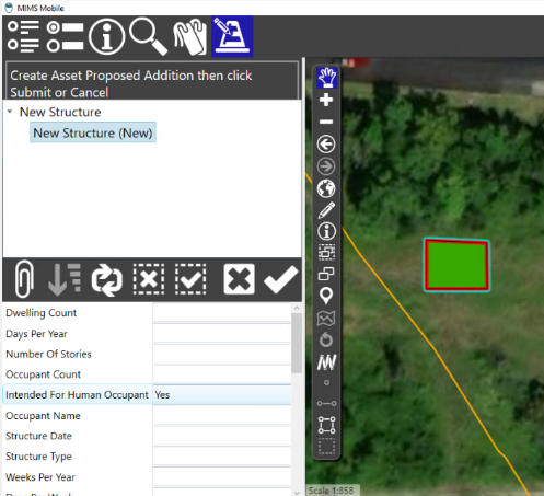
Along with a visual aid provided to the field worker the audit requirement of guaranteeing the actual location where the audit took place can be met by capturing the GPS coordinates of the auditor along with username and date and time stamps. Attribute data such as number of occupants, permanent, seasonal or temporary occupancy, and distance to pipeline, can be both verified and updated in the field. Using this technology your GIS will become the system of record with a full audit trail. Another data point that must be captured is the structure distance to the pipeline centerline. Utilizing the spatial information inherent in the GIS system, this data is easily calculated and can be stored as an attribute of the patrolled feature.

Adding and Removing Structures
Another important capability to consider is the ability to capture actual structure footprints. Your structure data may only be updated from a local source yearly and this may be true for your digitizing efforts as well. Therefore, the ability to continually update your base structure data becomes important to maintain compliance. This can be accomplished in the field as well, were the field worker can redline your maps with the footprint and attribute data during their patrol. Along with adding additional structures, you should also have the ability to remove structures that are no longer in existence, since you last patrol sessions.

Flexibility
The data that is presented to your field workers should be served up from runtime content that is generate from feature services, so all of your existing asset information is available to your field workers with the symbology and labeling that you define. You have the ability to search for any data element elements that you make available, provide base maps from Esri or ones that are generated from your own imagery. Utilize map navigation or show your location based on the GPS in your device. Because the content is derived from Esri feature classes you are in control of the data collected, deciding which fields are required and any fields that have domain values are presented to the field worker as drop down lists to ensure data integrity and consistency. Another advantage of utilizing data that is stored in a runtime compliant geodatabase is the ability to work with the data in a disconnected environment. This capability allows your field workers to continue to capture information even if there is poor or non-existent wireless signals. Additionally, when the runtime geodatabase is created from a sync enabled feature service, that feature service can be used as part of web map or operations dashboard giving full visibility to patrol activities to operations managers.


What do you think?