Customization
Intermountain Rural Electric Association (IREA)
Project Completed
INDUSTRY: Electric
SERVICES: Customization
Designer™ Customization Improves Multipage Staking Sheets at IREA
The Need
![]() Intermountain Rural Electric Association (IREA) wanted to create multipage staking sheets — complete with a job overview map and construction notes by map sheet.
Intermountain Rural Electric Association (IREA) wanted to create multipage staking sheets — complete with a job overview map and construction notes by map sheet.
The Background
IREA is a nonprofit electric distribution cooperative that serves more than 150,000 customers inside a 5,000-square-mile service territory along Colorado’s Front Range. IREA’s headquarters is in Sedalia, Co.
The Challenge
Out-of-the-box (OOTB) SE Designer™ provides the ability to create map books which can handle creating and saving multiple map sheets for a design/job. The OOTB tools will allow a user to manually select ArcFM™ map grid features which might include the work request polygon, PLSS grids, or any other custom polygon tiles. The user can then create a Designer™ map book which includes each of those tiles which should cover the job area. This provides a great starting point and SSP’s goal was to streamline and enhance these tools to create the ideal user experience.
IREA wanted to build customizations that allowed for an even smoother use of these tools for creating multipage staking sheets with job overview maps and construction notes by map sheet.
The Solution
The custom tools first come in to play after a user has opened a SE Designer™ design within ArcMap. One of the important requirements was that the design did not have to have a work request polygon defining the full extent of the job. If no work request polygon is present, our tools are smart enough to use the full extent of all of the work locations (construction/staking locations) to determine the extent of the job. This is key if you are creating a pole replacement design or similar job where the work locations might be geographically spaced out.
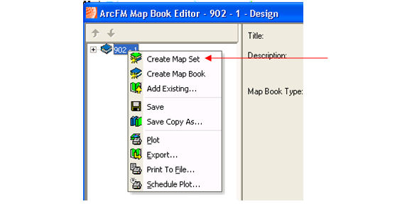
The first custom tool assists the user by automatically selecting the correct map grid tiles that provide the most efficient coverage for the job. The user opens the ArcFM™ Attribute Editor, activates the Design tab and right clicks the Design node. They see a new option:

Clicking the “IREA Design Map Grid Selector” option will present the user with a prompt that allows them to select the map grid tiles based on either the Work Request Polygon OR the Work Locations and then the form allows the user to choose the Map Grid Layer they want to use:

After clicking the “Select Grids & Launch Design Map Book” button, the tool will automatically spatially select the designated map grids based on the overlap with the work request polygon or the work locations. The Design Map Book Editor for the loaded Design will then be automatically shown. The user can now use the OOTB tools to right click map book to create a new Map Set:
Within the new Map Set, the user chooses the same “Layer” as was chosen in the custom tool above. The “Selected Set” button will become enabled (the grid tiles were previously selected automatically by the custom tool). Click the Selected Set button to add the targeted map grids to the Map Set.

If the user chose the WR Polygon option, grids will be added that cover the entire WR Polygon. If the user chose the Work Locations option, individual grids will be added to ensure coverage of all individual work locations even if they are not spatially adjacent.
Next, the user will click the options tab to configure the Display Settings to use an ArcFM™ Document that includes two data frames – the main display which will show the extent based on each map tile and an overview/locator map showing the full extent of the job.

 The next customization is a special extension that will automatically zoom the overview data frame to the full extent of the job based on either the work request polygon OR the extent of all the work locations. The user can now right click the Map Set and choose Plot or Export:


The individual maps will be plotted or exported with a single page for EACH map tile that was added to the map set. The overview data frame will be automatically zoomed to the extent of either the WR Polygon or the work locations:

 The overview map shows the red extent rectangle indicating where the specific map sheet is located within the context of the entire job.
The final customization we added was a custom ArcFM™ AutoText Element that would display construction notes (compatible unit details) for only the work locations that were present within the current map tile on each page. In the above example, that specific map grid tile only contained the first two work locations out of the total five work locations. Therefore the AutoText will only display construction notes for those first two work locations:


This AutoText element is typically placed in the upper right of the stored document. Without the spatial filtering in place, the AutoText item could potentially be VERY long for a large job (i.e., if it showed the details for ALL work locations). The spatial filtering allows the AutoText to only show the work locations that are currently visible on the current page. This keeps the text much shorter on large, multipage jobs AND is much more intuitive for the field crews because the construction notes correspond to what they are seeing on that specific map print.
Since we were creating a custom AutoText element we were also able to include some custom rendering of the CU data by utilizing some new extended data items. These included the guy lead length for anchor guys and the permitting type and authority for the non-GIS permitting CU. These are both also shown in the above screenshot.
The Results
All in all these customizations provided IREA with some slick new tools to further automate their workflow which will allow them to create better map plots for the field crews in a shorter amount of time. Everyone we’ve talked to who uses SE Designer™ to design large multipage jobs has found these suggestions valuable and we hope you will as well!