
Previously, we presented an idea to automatically color layers on a map based on Feeder ID. To read about the idea and see the solution we proposed, click here. We’ve been hard at work and we are now happy to say the tool is complete. The best part is we are giving it away for free. That’s right, absolutely, 100% FREE.
 Our network coloring tool is a button wrapped in an Esri Add-in. An Add-in is a relatively new tool that Esri added in ArcGIS Desktop 10.0. Add-ins were developed as an alternative to COM-based tools and to avoid the hassle of COM registration.
Add-ins are meant to be distributed as single user tools which plug straight into ArcMap, so as to require no extensive installer or extra programs on your computer. It’s as simple as double-clicking the .esriAddIn file and following the one-click process to install it.
Note: Add-ins can be easily managed in ArcMap by navigating to Customize -> Add-In Manager. In this dialog, you can view all of the Add-Ins currently installed and what tools are provided in each Add-In. Also, you may delete an Add-In by selecting the Add-In and clicking Delete this Add-In.
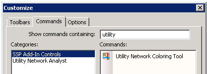
Once the Add-In is installed, you will need to add the Utility Network Coloring Tool to a toolbar of your choice. The custom button can be found by navigating to Customize -> Customize Mode… -> Commands tab -> scroll down to SSP Add-In Controls -> Utility Network Coloring Tool.
 Now that you’re ready to use the tool, let’s go into more detail about what our coloring tool does.
First, before running the tool, ensure that you have electric data in your stored display and the electric network configured for Feeder Manager is selected in the Utility Network Analyst toolbar. The tool is now ready to be kicked off!
The coloring tool will begin by collecting a list of feeders in the network, analyzing the network graph, and comparing feeders that meet at switchable tie-devices. From here, the tool creates a color map that is applied as symbology to each edge feature in the network that is a feeder. Depending on the size of the electric network, this process may take a while to complete.
Once the tool has completed, a new layer group named ‘Network layers with color’ will be created. This layer group will contain a duplicate of the network edge feature layers in the stored display that have Feeder IDs. These layers have all of the same properties as the layer they copy, with the addition of ‘(colored)’ in the name and some colorful symbology.
 The tool will work in ArcGIS and ArcFM™ Desktop versions 10.0.*, 10.1.*, and 10.2.*. You can download the Utility Network Coloring Tool for free.
Also, don’t forget to send us feedback on what you think of the tool and if you have any ideas on how to improve it. We appreciate any and all feedback.


Skye Perry says:
I had to put in a comment to give credit to our good friend, Bill Wickersheim of Burbank Water & Power. This tool came about as a request from him for the community. Internal to SSP we fondly call it Bill’s bad-ass coloring tool. But you can still call it the utility network coloring tool if you like it better! Nicely done!
motasem says:
when i use Utility Network Coloring Tool arcmap 10.2.1 crashing !!!