
Earlier this year, ArcGIS announced the ArcGIS Maps for Adobe Creative Cloud® beta release.
The product, ArcGIS Maps for Adobe Creative Cloud, allows users to seamlessly place and manipulate maps into Adobe Photoshop and Adobe Illustrator. This allows users to seamlessly place and manipulate maps in Adobe Photoshop and Illustrator.
Maps can be placed into Adobe as either vector layers or a high-resolution image, to be manipulated as necessary. This product works by first defining extents within mapboards; then you overlay layers, maps, and high-resolution images onto that extent. I recently joined the early adopter community to try out ArcGIS Maps for Adobe Creative Cloud beta. Here is my experience.
First Use: Testing ArcGIS Maps for Adobe Creative Cloud Beta
After joining and downloading the ZIP file, I ran a batch script which installed the extension without any additional effort. After installation, I could find the extension window within Photoshop or Illustrator. To do this, I navigated to Window → Extensions → ArcGIS Maps for Adobe® Creative Cloud®.

The “ArcGIS Maps” window requires you to log in with your ArcGIS account.

One you log in, a map is displayed. This is the central use of the current “Mapboards” tab. Here, you can choose a basemap, zoom into an area, and create mapboards.
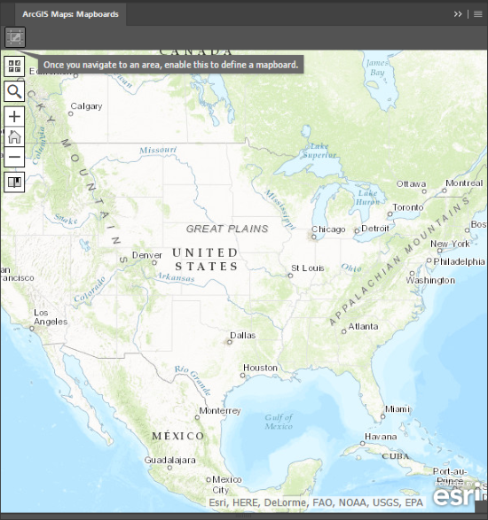
To create a mapboard, you draw a rectangle around a specific area of the map. You must give it a name, and can define its size based on either the size of the artboard or the scale of the map itself.

You’re then shown your new mapboard within the tab, and from here, you can switch mapboards, delete your mapboard, or add content.
The latter takes you to the “Compilation” tab, where you can change content for your map, which is where things get fun!

You can pick from some existing data templates, or find content within your organization that contains data within your mapboard’s extent. For our testing purposes, I’ll pick the public “Housing with Mortgages” map.
I think this will show a neat map when I take this into Adobe with ArcGIS Maps for Adobe Creative Cloud.

From there, all we have to do is download the map into a Photoshop or Illustrator file.
Beyond Mapboards: Into Adobe with ArcGIS Maps for Adobe Creative Cloud

In Photoshop, my image was loaded as a TIF file, with the copyright text and map loaded onto two separate layers.

In Illustrator, my image was created as a PDF with vector layers, which is very cool! This earned huge points in my book for ArcGIS Maps for Adobe Creative Cloud.
You can see that I can isolate a very specific polygon and alter its shape or other properties if I so choose.

Check out Esri’s blog post on ArcGIS Maps for Adobe Creative Cloud if you’re interested in learning more about the beta.
Remember that this version of ArcGIS Maps for Adobe Creative Cloud is still a beta, and as such, you may run into issues. With that said, you should be able to see the vast potential for this functionality.
The ability to download maps into vector-based layers or high-quality images directly within your Adobe design apps is a huge benefit for many users!

What do you think?