Electric utility companies may be required to provide a solution for tagging their underground electric lines for safety and regulation purposes. In the previous installment of Tagging Underground Electrical Lines in ArcFM™/Designer™ a solution utilizing ArcGIS 10, ArcFM™ 10.0.3, and Designer™ 10.0.3 was reviewed that met the following tagging requirements via Designer™ and Session Workflows:
- Generate a unique tag number for underground electric lines
- Assign a tag number to installed underground electric lines after design approval
- Append the phase to the tag number to identify the underground electric line
- Retain the tag number when replacing an underground electric line
The final workflow, Splitting Workflow, applies to both the Designer™ and Session Workflows and meets the following requirements:
- Retain the tag number on the source side when splitting the underground electric line
- Generate a unique tag number on the non-source side when splitting the underground electric line
In the Splitting Workflow a GIS editor will first select the Split Primary UG Line Tool button and click the point on the underground electric line where the split should occur. Once the split point has been placed a form will appear that will enable the GIS editor to:
- Select the side of the underground electric line that will retain the current tag numbers
- Split the underground electric line and assign the default ‘99999’ tag numbers to the new underground conductor phases OR split the underground electric line and assign the next tag numbers that are available to the new underground conductor phases
If the default ‘99999’ tag number is used for the new conductor phases it would be updated in the Designer™ Workflow by the nightly batch application and in the Session Workflow by the GIS editor. Both the Designer™ and Session workflows were described in the previous article if a review of these scenarios is needed.
After the underground electric line is split and the conductor tag numbers are updated a custom auto updater will populate the label text field on the underground electric line with all tag number and phase values for map display purposes. For an illustration of the scenario for splitting an underground electric line – see Figure 1.
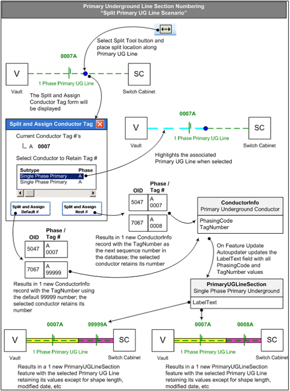 Figure 1 – Scenario for Splitting Primary Underground Line
This installment along with the previous month’s installment described a potential solution for Electric utility companies required to start tagging underground electrical lines.

Carol says:
A perfect reply! Thanks for taknig the trouble.