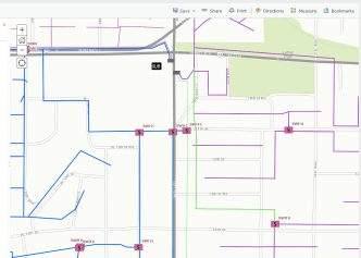
By deploying this WebMap, users will be able to view your electric network in a browser, desktop or mobile device, all tied to their ArcGIS Online organizational account. In this post I will unpack it for you and hope to encourage you to check it out!
Before we start, it is important to note that this WebMap does not require ArcFM Server™. However, because we will be working with ArcFM™ data, you will need to install the ArcFM™ Object Reader, which is a free component available from the Schneider Exchange website, onto your ArcGIS Server box (covered below) to allow it to read the ArcFM™ data.
If you already have ArcFM Server™ installed on your ArcGIS Server, you are all set and do not need the object reader component. NOTE: If you are going to use the ArcFM™ Object Reader, you will need the 32-bit version installed to use the data in ArcCatalog or ArcMap but will also need the 64-bit version installed to use the data with ArcGIS Server (which is a native 64-bit application).
The following steps all assume you are working in version 10.2 or later (10.2.1 recommended).There are good instructions in the getting started section of the Esri site so I am going to cover it at a high level here.
- First, download the ArcGIS Solutions zip file containing all of the required files from here.
- Unzip the files onto a box that has ArcGIS Desktop and either ArcFM™ Desktop or the ArcFM™ Object Reader as mentioned above. To simplify things, this same box may have ArcGIS Server on it as well, but Server could be installed on a separate server – if you are working through this you likely already know where your boxes are!
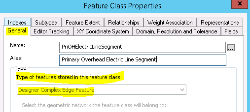
- There is a sample file geodatabase provided in the zip file called ArcFM_Electric_Sample.gdb. This data is from Minerville (Schneider’s sample data set) and while our savvy users may note that the MM_* configuration tables are not present, the feature classes are still ArcFM™/Designer™ classes (registered with the Schneider custom feature class extensions). You can always check this by viewing the properties of a feature class on the general tab:
This is the reason you either need ArcFM™ Desktop or the ArcFM™ Object Reader installed. Go ahead and browse around the data in ArcCatalog to get familiar with it, if desired.
- Next, open the ArcFM_Feeder.mxd file which was also included in the zip file. You can cancel the ArcFM™ Login screen if you have ArcFM™ Desktop installed as the sample database does not have the MM_* tables as noted above.
- Depending on where you unzipped your data, the mxd will probably load without any data reference (shows the exclamation points by all layers):
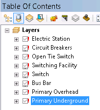
- Go ahead and click the exclamation point next to one of the layers, browse to the correct layer in the file geodatabase we reviewed in step 3 above and all the layers should be reset. Go ahead and save the mxd to save those updated layers. Your map should look like this:
- At this stage you should review the map and its properties. All of the layers are pretty straightforward, but note that the linear features (Bus Bar, Primary OH, and Primary UG) are all symbolized based on Feeder ID.
There are two points I’d like to make about this.
First, the mxd is using the Feeder ID field which is associated with Feeder Manager 1.0. If you are still using Feeder Manager 1.0 in your own data, this will work well. OR this will also work with Feeder Manager 2.0 once we have the new Feeder Sync tool that is being released in ArcFM™ 10.2.1a (coming soon in August 2014). The feeder sync tool will push the feeder ids from the in-memory 2.0 data store into the feeder id 1 fields after posting versions.
If you want to natively publish your mxd to ArcGIS Server using Feeder Manager 2.0, this can also be accomplished IF you have ArcFM Server™ installed. There are some additional intracies there – call us if you need help with this deployment strategy, as its definitely more complicated.
Second, if you are going to use your own data to publish a feeder map, you will need to symbolize based on your OWN feeder ids and not the Minerville sample feeder ids. You may already have a color by feeder map you can use. Alternatively, I would recommend checking out this post on a free SSP tool that will help you automatically generate color by feeder maps based on your existing feeder data! We’ve gotten great feedback on it, and heck – it’s free!
- At this point in time you will either want to continue with the sample mxd and the sample data OR create your own mxd off of your own data. If you want to use your own data, you can use an existing map document. You do NOT have to use the sample mxd. As a general rule of thought, avoid having too many layers in your mxd, as it will slow down the WebMap. The sample mxd does a nice job of providing a simplified map view of ArcFM™ data which will result in a well-performing WebMap.
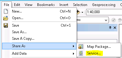
- Once you have your mxd ready to go, you can simply use the Esri File –> Share As –> Service wizard to publish the mxd to ArcGIS Server:
I won’t cover all the details of publishing in ArcGIS Server, as you should have a handle on that to be working through these steps. But do note that the solutions site has some good recommendations in this area on the publishing page.
- When you publish the data to your ArcGIS Server, if you are using the sample file geodatabase, the entire geodatabase will be copied to the ArcGIS Server (normal behavior). If you are using your own ArcSDE geodatabase, you will want to register the data source with ArcGIS Server before publishing the service. This will allow ArcGIS Server to reference the data from ArcSDE dynamically instead of copying it to the server.
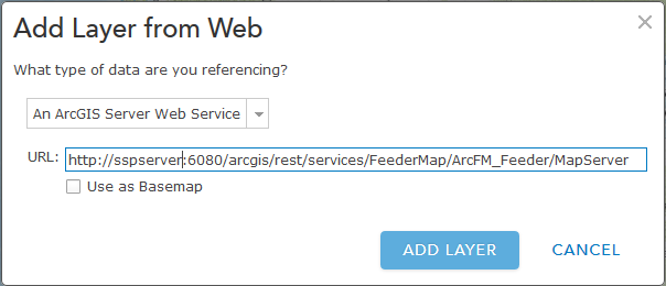
- Once the map service is published, you can grab the web service URL from your ArcGIS Server (example http://sspserver:6080/arcgis/rest/services/FeederMap/ArcFM_Feeder/MapServer) and add this to a WebMap within ArcGIS Online:
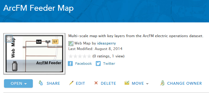
- And with those simple steps you will have an ArcFM™ Feeder map up-and-running in ArcGIS Online:
The ArcGIS Solutions site has some other good information about configuring ArcGIS Online pop-ups (remember, they will not respect your ArcFM™ field properties since this is straight-up Esri), adding a nice looking image (included in the zip) to represent the map to your users, and publishing the WebMap via a web application. Check those options out if desired and you’ll be in business.
This was a simplified approach to publishing a WebMap in ArcGIS Online. You will want to understand the configuration of ArcGIS Online Organizations including users, groups, security (internal, external, SSL, etc.), and sharing before a map like this will be ready for prime time. But these steps will get a sample map out pretty quickly and it will be viewable by anyone in your ArcGIS Online organization that you have shared it with, on any device!
And kudos to Schneider Electric for putting out an ArcFM™-oriented AGOL solution! If your organization needs any help with ArcGIS Online, especially when it comes to ArcFM™, please give us a shout, as SSP is the only utility-specific ArcGIS Online Specialty Partner.




Neal Myers says:
We are trying to publish some ArcFM layers using ArcGIS 10.2 (Note: Not 10.2.1) We cannot seem to find a version of Object Reader for 10.2. We understand that 10.2.1x is the prefer and recommended version but our server is at 10.2 and we are reluctant to upgrade and possibly affect other existing map services. So, since this article references 10.2 do you know which version of Object Reader should be used. We are also involving Schneider and ESRI but you guys (this blog is a good example) seem to have a good handle on the the process.
Skye Perry says:
Hi Neal, there is, in fact, specifically an object reader for 10.2. The file/version is Object_Reader_102_265.zip. There is also a patch for it – Patch_102_294.zip. I will email you to ensure you are able to get the files…