Over the past several years, SSP has been a leading voice in the utility and pipeline sectors of the GIS industry advocating for the use of available GIS technology to address regulatory compliance. This includes PHMSA regulations surrounding plastic pipe material tracking and traceability.
PHMSA – the Pipeline and Hazardous Materials Safety Administration – is the part of the US Department of Transportation that is responsible for setting standards and enforcing regulations for the safe transportation of energy and hazardous material resources. PHMSA regulations contained in 49 CFR Part 192, or the “plastic pipe rule” are one area where pattern based applications of GIS technology are well established and widely known thanks in large part to Tom DeWitte’s excellent Energy Advisor guest post back in December 2016.
These regulations mandate that pipeline operators track the installation location using GPS coordinates and record traceable asset information using barcodes that are present on the fittings and pipe that are placed in the ground. Tom DeWitte and Tom Coolidge from Esri recently published an excellent GeoNet blog post about updates to the Esri pattern for plastic pipe material tracking and traceability. The solution described in their article utilizes ArcGIS Online and ArcGIS Enterprise to seamlessly update enterprise GIS records with track and trace data. This GIS-based approach provides for the collection of track and trace data at the point of activity and appending it to the GIS automatically. Esri’s pattern provides an excellent framework that can be extended and further automated. It’s this approach to further process automation that we’ll discuss today.
Leveraging Enterprise GIS Technology
One important benefit to an integrated, GIS-based approach to material tracking and traceability is that organizations can accomplish both the field data capture and backend storing and reporting requirements without having to standup a separate cloud-based solution. ArcGIS Enterprise provides the ability to publish sync-enabled feature services – this is a capability that one can enable when publishing a feature service that allows for automatic updates to the underlying feature table via ArcGIS REST services. Both ArcGIS Online and Portal for ArcGIS support sync enabled feature services, and ArcGIS Runtime applications like Collector and Survey 123 can natively edit these feature services to directly updated the GIS. Many partner solutions natively edit sync enabled feature services too.
MIMS, which stands for Mobile Information Management System, is SSP’s enterprise mobile solution. MIMS is built on the Esri ArcGIS Runtime platform and provides utilities and pipeline operators with off the shelf tools to collect spatial data in the field to meet operational and regulatory requirements, as well as complete design and as-built process workflows. So how does it work?
GPS Location and Barcode Scanning
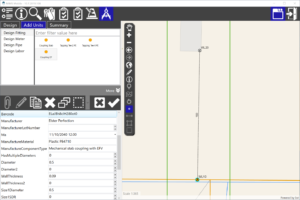
With the release of MIMS 2019 at the end of March, SSP added a new product plug-in that enables live decoding of barcodes meeting the ASTM F2987 standard for plastic pipe components. This solution is like the recent updates to the Esri pattern that utilizes Arcade expressions to decode barcodes, but it is configured via the MIMS Configuration GUI to map specific barcode defined attributes into the attributes of published ArcGIS sync-enabled feature service.
MIMS enables a field crew or inspector to quickly and easily capture data in the field at the point of activity and directly update GIS. MIMS is GPS enabled and easily interfaces with a variety of 2D and 3D barcode scanners. The GPS records the position of the asset and the scanned barcode defines attributes that identify a pipeline component’s manufacturer, lot number, production date, material, type, and size – taken together, these address the “tracking” requirements. All this information is automatically and seamlessly saved to GIS features in ArcGIS Enterprise and immediately available to locate, review and analyze – this addresses the “traceability” requirements.
What About Process Improvements?
The MIMS solution provides a few benefits when compared with the native Esri pattern. First, MIMS provides the capability to collect data, complete a survey and close a work request from a single application versus having to switch between a stack of apps. Second, MIMS natively edits ArcGIS feature services and allows for disconnected operation and automated synchronization of offline content into ArcGIS Enterprise – including both Portal for ArcGIS and ArcGIS Online content. Finally, the SSP process allows contractors and company crews to directly update the enterprise GIS – including an optional QA review – without the need to run a separate append process to copy data from AGOL to ArcGIS Enterprise.
Benefits of MIMS
MIMS offers many benefits to utilities and pipeline operators that are seeking an enterprise mobile solution to field-enable business processes. This includes the following capabilities:
- Native Esri GIS application – MIMS is an ArcGIS Runtime application just like Collector and Survey123
- Directly updates ArcGIS Enterprise – MIMS utilizes ArcGIS feature services and there is no post-processing required to load data into the enterprise GIS
- Uses existing solution infrastructure – MIMS piggybacks on your existing ArcGIS Enterprise deployment
- Support for many business processes – MIMS is not a siloed solution and offers support for a broad set of field-enabled business processes.
- ArcGIS platform-aligned – MIMS does not store data in a proprietary data format or in a private cloud
About the Author
Ian Martin is Director of Asset and Work Management Sales at SSP Innovations. He is primarily responsible SSP Lifecycle solution sales as well as integrated business process solutions involving SSP MIMS and SSP Productivity. He can be reached at [email protected].
More Information
It’s important to note that track and trace regulations are not the only ones that stand to benefit from the application of GIS technology and processes. My colleagues at SSP have written on the on the topic of using GIS for HCA and risk analysis and integrity management in HCA areas using enterprise mobile solutions.

What do you think?