
Tracking and Traceability: A Brief History
The ArcGIS platform and the ASTM F2897 specification for barcoding are playing an essential role in how gas utilities are readying themselves to satisfy the pending tracking and traceability regulations issued in May 2015 by the Pipeline and Hazardous Materials Safety Administration (PHMSA) of the United States Department of Transportation.
PHMSA’s proposed rules to 49 CFR part 192 address the need for operators to better “track” the details and location of assets after their delivery from the manufacturer or supplier. The rule also speaks to the need for better “traceability” of assets — meaning the ability to locate assets by material, size, manufacturer, model, or other attribute.
The ASTM F2897 standard, developed collaboratively by the natural gas industry and its leading suppliers, specifies a 16-digit alphanumeric barcode format that embodies identification of a pipeline component’s manufacturer, lot number, production date, material, type, and size.
Here’s how the ArcGIS platform and the ASTM F2897 standard are working together to apply to tracking and traceability. Natural gas utilities are using ArcGIS platform smart devices running Esri mobile apps to digitally capture at high accuracy the location of ASTM F2897-compliant barcodes on their installed assets and then auto-populating barcode scan-derived values back into their GIS database. Let’s look closer at how GIS is being deployed to address tracking and traceability requirements.
Pattern Overview for Tracking and Traceability
The ArcGIS deployment pattern for tracking and traceability is comprised of four steps, as illustrated here:
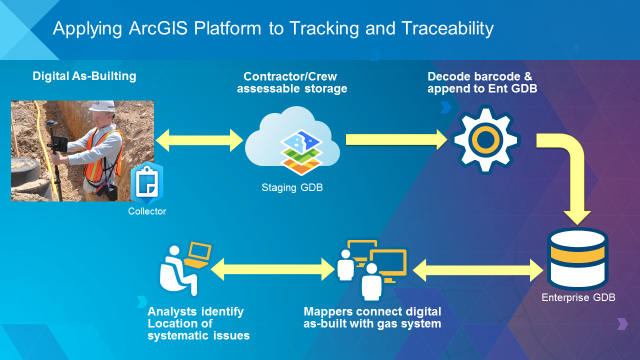
Step 1: Digital as-builting
There are several ArcGIS Platform-based mobile applications which have been proven to be capable of meeting this need. Esri provides the Collector for ArcGIS mobile application, which runs on Windows 10, Android, and Apple devices. This mobile client was enhanced in July 2016 to include the Trimble SDK to support Bluetooth communication to Trimble’s high precision GPS antennas. Esri business partners such as LocusView and CartoPac have built focused mobile solutions to further help simplify this field data collection process.
In this initial step, field staff use a smart device running an Esri-based mobile application. The smart device is typically Bluetooth connected to a high precision GPS antenna and a Bluetooth barcode scanner. The field staff uses the GPS antenna to capture the location of the newly installed assets. The field staff manually enter a minimal amount of information, such as Installation Date, and installation method.
The field staff then uses the barcode scanner to capture the barcode and automatically populate the BARCODE attribute of the GIS feature. The BARCODE value contains information about the asset, such as size, material, manufacturer and manufacture date. Once the BARCODE value is captured, the field staff no longer need to manually enter this information.
An additional capability of an Esri mobile app on a smart device is the ability to capture photos of the newly installed assets. These photos are automatically associated to the GIS feature.
When the field staff has completed the collection of the newly installed assets, the GIS features are submitted to the staging Geodatabase.
Step 2: Contractor/crew assessable storage
A fundamental challenge of tracking and traceability is how to correctly integrate high precision GPS geospatial data, with less accurate legacy geospatial data. A key component to overcoming this challenge is the staging Geodatabase. A staging geodatabase can be either hosted in ArcGIS Online as hosted feature layers or stored on premise with a local ArcGIS Enterprise implementation.
The key purpose of the staging geodatabase is to provide an easily accessible data repository for the field crews to submit their collected construction information too. The staging geodatabase only holds the newly collected construction information. The construction data sits in the staging geodatabase until a mapping professional using ArcGIS Desktop accesses and downloads it to the Enterprise Geodatabase.
Step 3: Decode barcode and append to enterprise geodatabase
One of the time saving capabilities of ArcGIS Desktop is the ability to interact with data from both the staging Geodatabase and the Enterprise Geodatabase at the same time. This allows the mapping professional to easily select the staging Geodatabase features and append them into the Enterprise Geodatabase. To streamline this simple but repetitive process, Esri has put together an ArcToolbox python tool which automates the following:
- Appending all selected features in the staging Geodatabase into the correctly mapped Enterprise Geodatabase featureclasses.
- Correctly decoding the Barcode value per the ASTM F2897 standard.
- Automatically placing the decoded values into the correct attributes for the asset.
Step 4: Mappers connect digital as-built with gas system
With the new construction data now appended from the staging Geodatabase into the Enterprise Geodatabase and the barcode value decoded, the mapping professional now needs to determine how to connect the high precision geospatial features with the less accurate geospatial features. The outcome of this process needs to honor two data requirements:
- Connecting the new features with the legacy features to create a single topologically connected gas pipe system.
- Preserving the high precision GPS collected geospatial coordinate data.
The recommended best practice for accomplishing this seemingly disparate set of requirements is for the enterprise Geodatabase point features such as Meters, Excess Flow Valves, and non-controllable fittings to have the following attributes added: SPATIALACCURACY, GPSX, GPSY, GPSZ. The GPSX, GPSY and GPSZ numeric fields can be automatically populated with an attribute automation tool like Esri’s Attribute Assistant tool or ArcFM’s AutoUpdater capability.
This will preserve the original GPS location values, which can be used later to rubbersheet all features (legacy and GPS) to the more accurate GPS location preserved in the GPSX, GPSY, and GPSZ attributes. With the GPS location preserved, the mapper can adjust the new construction features as required to connect to the legacy gas pipe system.
Business Value of Using ArcGIS for Tracing and Trackability
This approach to Tracking and Traceability provides an opportunity for the GIS department to once again show the greater gas organization that not only can the GIS Department provide a solution which addresses this new regulatory requirement, but it can do so in a manner that improves the operational efficiency of the gas organization. This pattern improves the operational efficiency of the gas organization as follows:
- Using Esri mobile tools to collect construction data improves location accuracy and attribute quality by eliminating translation to paper and interpretation of paper based information.
- Bluetooth integration with barcode scanners and high precision GPS antennas improves the speed at which data is collected.
- Capturing the barcode value reduces the amount of information the field staff manually collects. Material, diameter, manufacturer, manufacture model, manufacture data, manufacture lot# are all automatically populated by the decoding of the barcode.
- Digitally collected data is immediately available for GIS department to process into Enterprise Geodatabase. This eliminates the historical latency problem of the GIS Department waiting for the inner office mail transmittal of the construction packet.
- The GIS department mapping professional task of updating the as-built representation of the gas pipe system is simplified. The mapper is no longer manually transposing paper based red-line drawings, but instead appending field collected geospatial features. This improves the speed at which a mapper can complete the task of updating the as-built representation of the gas pipe system.
- Safety of field operations staff is improved by providing the new construction data in a timelier manner.
This deployment pattern not only provides the ability to improve the efficiency of the field data collection; it also improves the productivity of the mapping professional, and provides new construction updates to locators and field operations staff in a more timely manner.
Download Tracking and Traceability Deployment Sample
You can download a tracking and traceability deployment pattern software sample at:
[URL to GeoNet Posting]
SSP is pleased to have Tom DeWitte — Technical Lead at Esri — collaborate with us on this blog post. Tom started at Esri in 1998, and for the past 14 years has focused on supporting the Natural Gas Industry. Tom is the curator of the Utility and Pipeline Data Model, UPDM.

Rob Harris says:
Love the staging database concept. For the field user, are there any recommended barcode scanner devices that work well in full sunlight or in a trench where the lighting is not optimal? Also, how are you handling prebuilt assemblies? For example: a mainline tee/18″ section of lateral/reducer/6″ section of lateral/excess flow valve? These all may be preassembled with a total square footage of less than 3’x3′. Due to the sizes, bar codes may not be visible.
Tom DeWitte says:
Rob,
The barcode scanner that was recommended to me by a gas utility was the Socket Mobile 800 series scanner. It communicates via Bluetooth and works with Apple devices.
Handling of Facility assembles like a service tap assembly is a two-part question. The first part about how field staff will deal with capturing GPS data for so many assets in such a tight location is a question best addressed by those who wear steel toed boots. The 2nd part is how to manage this data within the Geodatabase. Later this summer Esri will be releasing the Utility Network. As shown in a great video created by SSP, the new Utility Network Container capability will be a key component in helping mapping technicians to enter and manage this very locationally dense set of features.
phil harris says:
Very interesting article. There is concern in the gas industry as to how far the ruling will go (i.e. how do you record spatial gps data on directional drilled assets/butt fusion joints)? The gas technology institute is also working on this through their OTD area and finding was to address issues like “urban canyons” where gps is difficult to obtain.
Tom DeWitte says:
Phil,
Great comment. There will definitely be a need for AGA to help the industry define best practices for how to collect the location of direct bore features. On the GIS data management side of this question, we at Esri are actively working to update our best practice data model, UPDM to model and store this information.