
Right-sized and aligned, such a simple concept. Acquire the technology that you need – no more and no less – and acquire technology that plays well with your existing investments. A humble approach, but with broad benefits for many stakeholders throughout the utility. For leaders within the GIS organization, budget savings, and relieving schedule pressures become apparent when implementing technologies that were conceived to complement each other. For utility, IT organizations, lower risk, and improved support are the result of working with technologies that are architected and designed to work together rather than the opposite when issues arise such as a modest support ticket or a more complex performance problem. For CIO’s and Vice Presidents, implementing out-of-the-box complementing technology has the critical value of spending fewer resources solving foundational needs while allowing for more time and effort to solve the next segments of strategic problems and risks within your departments.
A TECTONIC SHIFT is underway in geospatial tech. The Utility Network is a prominent center-stage capability, far surpassing its predecessor in function and form. ArcGIS Portal cemented itself as a central authority and rally point for matters of the GIS ecosystem, including security and identity management, licensing and configuration, sharing, and collaboration. ArcGIS Server quietly underwent an architectural overhaul, which paves the way for a more scalable microservices infrastructure, and that in itself translates to cheaper, better, and faster.
What’s not to like? And what are you doing about it?
Many seized the opportunity to step back, gather a fresh perspective, assess how well, and to what extent the business is leveraging its geospatial investment. There are many factors to consider here, though, and many of those situational. However, two simple questions that are generally applicable to an investment of any sort are “where is the investment being made” or what are the primary components, and “how successful has it been (or will be)” or return on investment. And, just like any investment, periodic review is required to ensure a continuance of success with alignment and sizing.
Right-Sizing
When first introduced in North America, cable multimedia had a dozen channels and some premium content in select areas. Over time, and in the absence of any real competition, the cable providers added more channels, more content types, and more choices that customers did not request. As content exploded, costs went through the roof. Customers paid full price for full access and used only a fraction.
Market and technology finally swept in with, and pay-per-channel offers and “streaming sticks.” And now, customers are getting back to paying for only the content they want and need and at a fair and appropriate price.
Similarly, the newest additions to core ArcGIS necessitate a review of current subscriptions of supporting 3rd party software. As we will see, many functionalities previously only available through customization, are now present in a base deployment and configuration of the ArcGIS platform. Not only that, but many of these platform additions also come with additional capabilities and benefits that could not otherwise be realized.
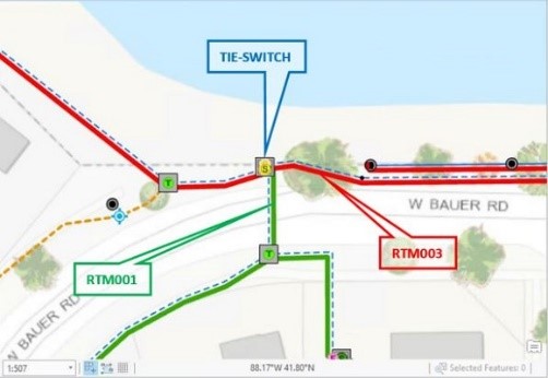
Subnetwork Management
The Geometric Network, first introduced in ArcGIS 8.0., was a technological feat for its day. Purportedly architected single-handedly by a former Bell Labs savant, it represented the first official foray into network topology and modeling as a core capability. It was, and still is, a capable model, both elementary and generic as its designers intended. After its first release, Esri partners quickly churned out network models representing real-world utility assets, among others. Applications that utilized these models quickly followed, cementing the concept of an interconnected world waiting for someone to unlock unique perspectives.
The Utility Network network model is both evolutionary and revolutionary in its design. Network types have evolved in seemingly innocuous ways. Network edges, now dubbed “lines,” are made up of sub-parts or “subnetwork lines.” Generic network nodes remain in the model as junctions and also add a new junction type, the “device”. Devices have terminal inputs and outputs and thereby a means to model network directionality, a big step forward from the previous model where directionality had to be inferred.
The biggest gains come from these lines, junctions, devices rolling up to compose a “subnetwork.” A subnetwork may have specific behaviors and characteristics unique to it. The subnetwork has built-in automated summary information (e.g., total kVA, max operating pressure), and it leverages the topology to streamline and simplify bulk editing tasks with its smart attribute propagation.
Joaquin Madrid provides an excellent walkthrough and breakdown of these Utility Network capabilities in his review of subnetworks “Subnetworks & Load Swap.”
 Attribute Rules
One challenge in earlier versions of the Esri platform was how to fold in business logic or corporate data requirements into everyday workflow. Third-party solutions filled the gap with customizations that intercepted edits made to the geodatabase, which then opened the door for users and businesses to add and automate the requisite data more easily and consistently.
Similarly, the new platform brings an Attribute Rule framework that allows the specification of these rules via its proprietary Arcade language. No compilers needed either. One can now intercept and inject business logic through a simple textual configuration. What’s more, rolling out is a cinch; they can be applied and utilized across all supported platforms simultaneously, credit to its services interface.
Caleb Melies has a nice writeup on what these rules look like how they work and getting them right in Streamlining Edits in the Utility Network With Attribute Rules
Enterprise GIS
 Esri CEO and owner, Jack Dangermond, has long been a storied champion of collaboration and data sharing – as individuals, as groups, as industries.
We embraced the concepts; however, the core platform wasn’t quite there yet. For example, sharing a map using core tools at the time felt like more work than it should be. Third-party integrations stepped in, filling this gap by bringing the data closer to the user through direct integration inside the application with a list of maps users could use or share with others. Custom integrations also took a similar approach with print layouts providing an easier mechanism to keep map products consistent and up to date in the organization.
These vendor-provided technologies quickly become mainstays, allowing users to effortlessly do what Jack told them they should do “share, compare, and derive.”
ArcGIS Portal serves as the locus of all geospatial maters directing the user to content or cataloging and indexing it for fast, secure retrieval. With direct, in-applications integration with Portal, ArcGIS Pro now provides those benefits formerly only found in aftermarket customizations.
More centrally accessible data feels natural to use and maintain, it is more easily shared with other individuals, co-workers, and teams, the organization, or even the public at large.
Services Architecture
Lastly, there is an underpinning service architecture and infrastructure enabling it all. Legacy architecture and vendor-provided solutions were by virtue of the system, client-server based. In a client-server model, customizations had to be replicated or installed where they were needed. Even a modest system architecture required laser focus to keep the dizzying array products and components in line and up to date.
Further, some of these older capabilities were only possible through tight coupling with data, which in turn placed more restriction and constraint. Ultimately, this client-server architecture required a carefully synchronized upgrade effort.

Through the new services design, many of these impediments become non-issues. Data access, applications, and capabilities thereof can more easily coexist with disparate data sources, versions, and applications. In fact, the services architecture provides support for an ecosystem with parts old and new simultaneously.
By virtue of being service-oriented and cross-version compatible, there is an inherent requirement of scale. That is since the system can be utilized by many different applications located anywhere on any device.
Services sidestep runaway scaling costs by spreading the work across the system. Components can scale independently and where most needed instead of wholesale yielding a return that is more bang for the buck.
And now that you’re doing more with less, you can make good use of that time and true up the next part of getting things right and moving in the right direction.
Now you have more time to focus on strategic alignment with an eye toward the future.
Less time making it work, more time on the next strategic initiatives.
Stepping back and considering your utility’s enterprise-wide geospatial strategy beyond what is currently understood to be the existing GIS, involves assessing the future needs and value of everything associated with your utility’s record and representation of the transmission and distribution networks. That is, the digital twin. And it includes understanding what your future needs will be for the accuracy, fidelity, real-world modeling, state, and latency of your spatial information. As an example, accurate and up-to-date modeling of the distribution grid is foundational to many other current electric utility initiates such as the integration of distributed Solar + Storage and EV’s.
An updated enterprise-wide geospatial strategy should also be inclusive of assessing newer technologies such as remote image capture via drones, machine learning image recognition, 3D and augmented reality solutions, spatial analytics & insights, and enterprise spatial business intelligence & operational dashboards.
Right-sizing your investments around core Esri technology is not only a practical move to more efficiently solve your existing needs, but keeps you aligned and in a position to use the enhanced capabilities of the core Esri platform as they are continually invested in and become available. Simply put, aligning today will ensure your success tomorrow (and for years and years to come).
SHIP IT
The changes in geospatial tech are massive and can be a bit intimidating, but there is a silver lining. The move is to a more responsive, dynamic, flexible, and capable GIS platform. Revisiting old “channel subscriptions” will uncover opportunities to declutter, lock in what the business needs and leverage the core platform and capabilities, and do what is best for the long run. Instead of spending time nurturing and working around legacy systems, build out the foundation on a modern, capable system.
Now is the right time to seek out and assess what is needed and where it is headed. There is no better time to get sized, aligned, and ready for growth. One thing is certain, harder problems to solve are on the horizon. Be ready. Be prepared. And as they say in the product world, ship it!

What do you think?