Introduction
Over the past 20 years, GIS has evolved into one of a key group of critical systems every pipeline operator and gas utility relies upon. While many systems are still functional, there are substantial underlying issues, such as vertical integration or the growing enterprise integration gap, that still need to be addressed. Those issues are driving organizations to reevaluate their existing solutions and migrate to more modern systems through several viable market options, which is a big step for many operators. So, it is important to understand the advantages and key considerations that define the direction of evaluations, pilots and, ultimately, the business cases.
What are the options?
When an organization decides it is time to rethink their pipeline system GIS, there are two primary options available:
- PODS 7.X – a choice for existing PODS transmission users who have stable systems and would like to minimize change and costs. This model is a spatial model, unlike earlier versions of PODS (i.e. PODS 4.X), which were relational database models. For example, this allows for the spatial location and attribute information to be stored within the same record row.
- PODS 7.X with Utility Network – Esri’s Utility Network (UN) allows users to manage ALL assets (from well head to meter) in a fully networked model. Transmission Oil & Gas operators have been unable to do this in the past because Esri’s previous generation network model (geometric network) was unable to support these linear referencing requirements.
- UPDM – The UPDM is the Esri developed pipeline data model and is designed for those operators looking to significantly modernize their systems and take full advantage of Esri’s powerful technology. This is also a spatial data model, which provides a seamless integration to the core Esri platform. Meaning, should Esri make changes to their core product line (ArcGIS, etc), it’s up to Esri to ensure these changes will not affect the existing data model.
- UPDM with Utility Network – Esri’s Utility Network (UN) allows users to manage ALL assets (from well head to meter) in a fully networked model. Transmission Oil & Gas operators have been unable to do this in the past because Esri’s previous generation network model (geometric network) was unable to support these linear referencing requirements.
As the PODS organization has working groups and documentation covering PODS 7.X, this article will focus on the UPDM/UN option. However, keep in mind that the level-of-effort, costs and benefits will be similar between the two platforms. The following sections break down the advantages into three specific areas that any organization should consider before moving forward: Technology, Cost and Engagement.

Technology
When an organization chooses to implement the Esri UPDM/UN platform they immediately receive a long list of benefits that empower users and support strategic goals while minimizing development, support, and integration costs. The platform provides the tools needed to meet an organization’s needs.
- It is a single system – Out of the box you can manage transmission (linear reference) and distribution (network) in a centrally managed, single environment (geodatabase) which can support huge amounts, and a wide diversity of information such as feature data (asset, ILI, Risk, Geographic), IOT or real-time measures.
- Delivers on Technical Requirements – It inherently supports numerous industry requirements like being natively spatial, geospatial coordinates and measures, connectivity, topology, containment, schematics, stores/displays many types of imagery (LiDAR, etc.), and is 3-dimensional.
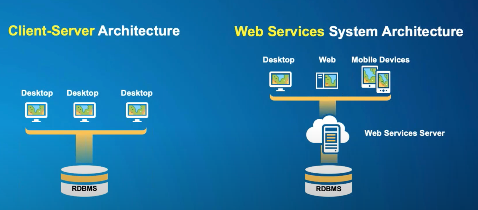
- Unites the Entire Organization – It is built for mobile, web, desktop visualization and single machine, server, or network (server, network or cloud) content storage and analysis.

- It Scales and Delivers on Industry Use Cases – The platform can facilitate a comprehensive view of your entire network yet scale down to dense areas of your system without map clutter (containment) and support the entire process lifecycle including an expansive set of business use cases like Traceability, QA/QC, Emergency Shutdown Analysis, Outage Management, Integrity Management, TRV, and Risk…and how to facilitate details like MAOP or piggable route tracing.
- Supports Analysis and Answers Questions – It support most modern program languages and has a wide array of native modeling solutions like ArcPy, geoprocessing or Notebook server. All of this supports the simple and powerful automation capabilities in either code or using scheduling tools.
- Native Data and System Integration – the platform has support for hundreds of data formats, reads information from virtually any database, consumes and shares data through services, and has a platform for developing import/export workbenches. If system integration is a concern, there are proven methods for integrating Esri solutions with key enterprise platforms for work and asset management, design, document management etc., as well as enterprise architectures.
- 3rd Party Solutions – The partner community has developed powerful industry specific solutions to support Integrity Management, Risk Assessment, MAOP, Class, HCA, MCA etc.
Cost
Any new system comes with a price tag. The price is generated from three general areas:
- Data – the cost to update, expand and migrate your information
- Implementation – the cost to configure, customize, implement, and integrate the system
- Licensing – cost of platform, application, and 3rd party licensing
Every organization’s challenge is to maximize the value of a new platform by addressing as many business processes as possible. However, this methodology requires prioritization and compromise. Because the UPDM/UN option involves the deployment of a platform-based solution there are a number of inherent advantages:
- First, everything has a common platform, so it is less complicated to own and operate; it requires less integration, fewer databases, and it has proven methods for extending and connecting.
- Second, it is a standard environment, not a custom one, so there are other users you can learn from and evaluate solutions/processes and thereby decrease your costs and learning.
- Third, the majority of the software costs are covered by a single licensing agreement, and it minimizes the amount of third-party software required.
- Lastly you can take advantage of a scalable license configuration allowing you to manage costs by using the right license to do the right thing; for example, simple editing can be facilitated by a web client, or field work is done using a mobile license.

The GIS System of Engagement
While this paper touches on the advantages of Esri’s Utility Network (UN), perhaps one overlooked advantage is the ability of UN/UPDM to aid in the enhancement these Esri based Enterprise GIS platforms from a traditional system-of-record to an enterprise-enabling system-of-engagement. GIS as a system-of-record has proven invaluable over the decades and is used to collect, manage, and compile geospatial information in maps to improve overall business decisions. However, GIS as a system-of-engagement (as defined by Esri’s President Jack Dangermond), “applies the benefits of geography—of maps—everywhere, across organizations and communities, in a way that invites participation from everyone: employees, customers, partners, and citizens. Thus, it is not just about collecting and having information; it is about empowering everyone in an organization (and in that organization’s community) to access and understand it.”
GIS systems have traditionally been owned and maintained by a small number of individuals within pipeline organizations. While powerful, the ability to disseminate GIS information quickly and easily was, and in many cases still is, a difficult task for many GIS departments. This has often been one of the primary reasons GIS has remained within the system-of-record realm. However, this platform and mind-set are outdated, and enabling the GIS as a system-of-record has become a key business driver for GIS system upgrades and evolution. So, what are a few ways UPDM can help extend the reach of your system-of-record GIS content?
- First and foremost, it uses maps: Sure, a traditional GIS uses maps too, but these new platforms are geospatially based and use maps as the foundation for communication. If you are looking to engage people through an organization… a map is often a great place to start. Just consider the ways we utilize maps in our everyday lives, and how that usage has increased over the past decade with more and more of our daily information directly leveraging maps. The ability to access, visualize and understand geospatial information quickly and easily via a multitude of technology and devices is a great example of how new users are becoming engaged.
- Map services, Mobility and Web Applications: Mobile devices and web browsers are extremely common and easy to use interfaces. This allows for the access and leverage of cloud and mobile technologies more quickly and easily. The other benefit is a scalable solution that is much more cost-effective. Simply put, map services are a highly consumable way to deliver data. The combination extends the reach of information and drastically reduces the time needed to develop and release solutions. Esri configured data models, like UPDM, are built to utilize this data deployment along with modern software/content development avenues.
- Opening the door and sharing: UN/UPDM models utilize the open Esri environment. When content is loaded into the models it goes from being hidden in a closed, proprietary system to residing in an open, shared environment. Content is exposed through services and API’s so it can be accessed by other systems or platforms. Those users can create derivative information, which can be shared back using the same model. We are in an era where business and IT leaders are tearing down silos to get new value from existing information and answer ever more challenging questions. This is the foundation of engagement!

Where do I go from here?
Making a change can be a costly, scary, and risky process. While we have provided some valuable insights into why you should make a change, the next steps (like business case development) require expertise. You need to identify:
- Where should you develop immediate programs to update or supplement existing data
- A solution that fits into your IT infrastructure
- A realistic company roadmap to move forward
Our organizations have extensive backgrounds in PODS/UDPM/UN migrations, implementations, integrations… and can certainly provide help with everything discussed thus far. However, regardless of who you choose to work with, ensure they understand the industry, the system, and the program of work you have on your horizon to ensure a successful Utility Network deployment.


What do you think?