Over the last several years, we have been implementing a lot of mobile GIS solutions at utilities across the US. If you are a regular reader of our Energy Advisor newsletter or our blog, then you know that we have been heavily covering Esri’s new ArcGIS Online offering with a focus on taking your GIS operations to the field (pole inspections, outage maps, customer engagement, etc). While we do believe ArcGIS Online is the way of the future and will continue to look for new and exciting ways to implement the solution, it should be noted that utilities are by-and-large still pushing for a fully disconnected solution with a local data store.
The main driver behind disconnected usage is that utilities need their mobile apps to restore outages in storm scenarios, and that is often exactly when they might lose the cell coverage that provides the life blood of any connected mobile application, including ArcGIS Online. Or at a simpler level, utilities provide service to the vast areas of our country where there may be little to no cell coverage at all. In both cases, a disconnected solution provides a powerful option with all the whiz-bang benefits of a desktop application.
 So in that context SSP has primarily been implementing Telvent (previously Miner & Miner and now Schneider Electric) ArcFM Viewer™ for ArcGIS Engine. The ArcFM Viewer™ application is typically deployed with ArcFM™ Replication which handles keeping the back office central GIS updates pushed out to the mobile computers. It also handles moving redline and inspector mobile edit sessions from the field to the back office GIS. And that’s the topic we want to explore further. ArcFM Viewer™ provides two optional edit-related extensions – Redliner and Inspector.
Redliner allows field personnel to mark up the map using free hand drawings, text, and graphics to inform the back office of map corrections or other conditions that might affect the data in the centralized GIS. Inspector allows for the creation of field inspection events for existing facilities such as poles, pads, switches, regulators, valves, etc.
In addition to creating new inspection events, the Inspector extension allows users to edit attributes of existing GIS features and objects. For example, this handles updating the height and class of a pole or the size of a valve. These edits are transferred to the back office alongside the new inspection events within a mobile edit session.
This product functionality covers a large number of use cases, but the one missing area is the creation of new GIS features in the field. This could be used to collect missing facility data, new damage assessment areas, or even brand new datasets.
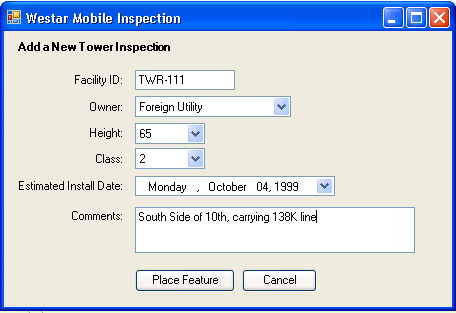
SSP was recently asked to prototype a custom extension to ArcFM Viewer™ to allow for the collection of new transmission tower data. We worked with Telvent’s sales engineering team to come up with the technical approach and then implemented a simple example. The intent would be for a user to turn on the product-based GPS integration for ArcFM Viewer™ which will continually zoom and center the map to the current GPS coordinates. The user then clicks a new custom button on the main toolbar to launch a data collection form:
Because this is a custom solution, the collection form can use any format. In our example, we simply added a few fields with intuitive controls including domain-driven pick lists, a date control and text boxes. The goal of a mobile data collection application is to make the data entry as quick and painless as possible. The target hardware should also be taken into account, as many mobile deployments may use tablets with a touch screen or a stylus which may impact your form design.
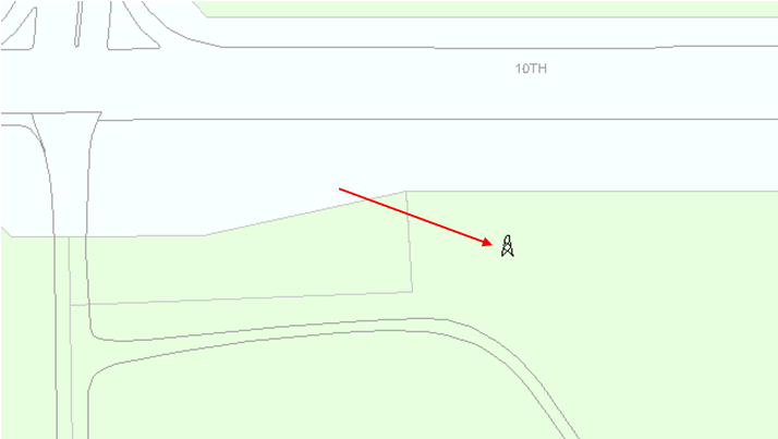
Once the data has been entered, the user can click the Place Feature button to add the feature to the map. One option would be to automatically add the feature at the current GPS location and then allow the user to move the feature. Or we could allow the user to place the feature manually based on the reference data on the map (streets, parcels, etc):
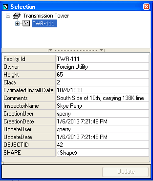
Within the context of a mobile session, this new feature is an actual GIS feature including both shape data and attributes. It can be selected, viewed, and even edited within the ArcFM Mobile™ Selection Tab:
Even though the feature appears to have been committed to the geodatabase, the same product software that handles capturing and transferring inspections and attribute updates within a session is monitoring our new feature additions. We can augment the new feature data with additional redlines and then send the session to the back office:
Once the session has been sent to the back office, the edits are removed from the mobile map because they are associated to that specific edit session. We did not have to add any additional code to allow this to occur as it was handled via the ArcFM Viewer™ product. When the session is received in the back office it can be opened within ArcMap. ArcFM™ handles replaying the mobile edits including the redlines, inspection events, any attributed updates, and finally – as you guessed – our new feature additions.
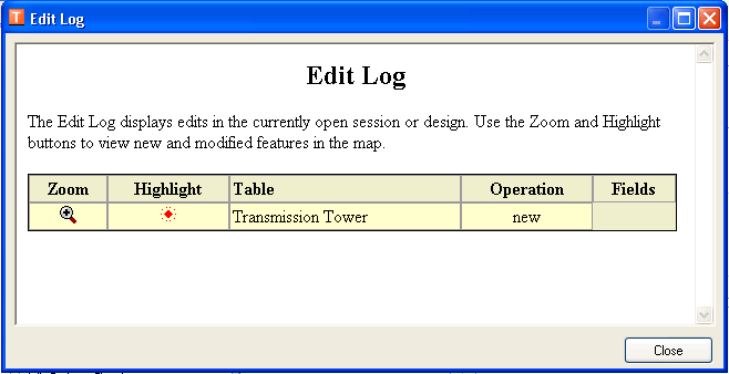
The edits can be viewed on the map and via the ArcFM™ Edit Log:
The beauty of this solution is that it utilizes all of the existing out-of-the-box Telvent software for tracking, transferring and replaying the mobile edits into the back office. The only customization we had to write was the tool to allow for the creation and collection of the new data.
Like us, you may be asking, why then isn’t this part of the ArcFM Viewer™ product? We talked at length with Telvent leadership and it really comes down to some additional limitations when creating new data in the mobile environment. Specifically you cannot create new network features because of the additional complexity of the geometric network and limitations in the ArcGIS Engine platform. But with that said, everything else works just as you would expect.
We found this to be a very useful extension to ArcFM Viewer™ and hope that it may open some new doors for your mobile operations by allowing you to collect new data in the field. If you have any questions or comments we are always happy to answer them.



What do you think?