Quick Question! How many states are in at least two pieces?
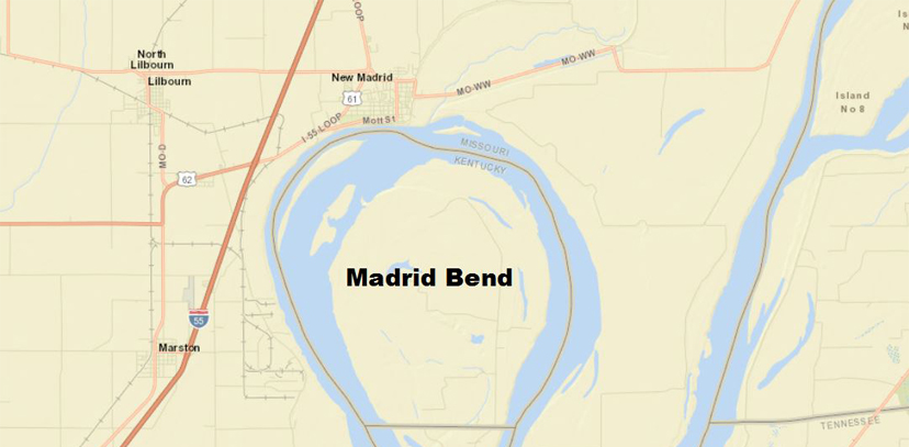
A piece counts as two legitimate land masses of substance; so a piece does not include a little rock island off the coast. For an example of a state in two pieces, consider Kentucky. As everyone knows, there is an area in far western Kentucky called Madrid Bend that is formed from a meander of the Mississippi River and surrounded by Tennessee and Missouri (Figure 1). So how many are there? We can use some lesser known GIS feature types to help us answer this question!

When a user creates a new feature class within ArcCatalog (usually by right-clicking within Feature Dataset → New → Feature Class), the user is presented with a list of standard feature types (Figure 2).

Most GIS nerds (like me) are familiar with the following types of feature classes:
- Point
- Line
- Polygon
- Annotation
There are three other, lesser known GIS feature types that are probably less common and worthy of a blog post. These lesser known GIS feature types include:
- Multipoint
- Multipatch
- Dimension.
Each will be broken down in the rest of this blog post.
GIS Feature Types: Multipoint vs. Multipart
The Multipoint GIS feature type is used to denote multiple point features as single entity with a common attribute table. This multipoint feature type is not to be confused with the multipart line/polygon (more on these later). Esri uses the example of the entrances/exits of a prairie dog den (See Figure 3) to understand multipoint GIS feature types. I have never tried, but I would assume that is extremely difficult to map the actual underground den of a prairie dog, so the common attribute table applicable to the den is applied to the multiple surface holes.
The multipoint feature is created (as in chosen from the drop-down menu in Figure 2), digitized, and then field attributed exactly like any other feature class except all point components are placed prior to completing the sketch. Once the sketch is completed, one attribute table will apply to all points digitized.
Multipart features involve disconnected lines and polygons. Like the multipoint feature type, the disconnected features share a common attribute record, BUT they do not require a special feature class designation.
There are a few ways to create a multipart polygon. We are going to utilize the Kentucky boundary example. We first digitize the Bend as a polygon feature (shown if Figure 4 in a random color of blue).

With the polygon feature enabled for editing, click on the “Continue Feature Tool” on the Edit Vertices toolbar (See Figure 5).

We can then digitize the rest of the Commonwealth of Kentucky. Upon conclusion of the main body of Kentucky, we have two polygon parts that behave as a single feature with common attributes (Figure 6).

It should also be noted that the multipart polygon could also be digitized via another method. At the conclusion of digitizing the Bend, right-click to obtain the context menu, choose Finish Part, and digitize the disconnected polygon(s) (Figure 7).

Second of the Rare GIS Feature Types: Multipatch
Confession is good for the soul, right? Well … Here is a confession! I had no idea what this type was, which is exactly why I started writing this blog post. In researching all sorts of GIS feature types, I got deep into the 3D Editor toolbar, ArcScene, creation of 3D base layers, and so on. Although I had a fun time, I quickly got out of my comfortable utility GIS world of 2D points, lines, and polygons — straight into some lesser known GIS feature types.
It is very good thing to sometimes be uncomfortable and learn something new.
There are several future potential blog posts here, but beyond the purpose of this post.
So … What the heck is a multipatch feature class type? A multipatch feature is used to represent objects in 3D space. The key word is volume. An object like a building or other large surface landbase features could be represented in this type.
Last of the Rare GIS Feature Types: Dimension
The dimension GIS feature type is similar to the annotation feature but leverages the GIS environment to represent actual lengths.
The ArcCatalog creation of a dimension feature class type is straight forward. The only real decision that must be made is the declaration of a reference scale and style. The reference scale should match the anticipated application. Figure 8 shows the scale of 1” = 100’ ft (1:1200).

One may also choose the style by choosing the “I would like to create my own style” option and clicking the “New Style” button (See Figure 9). In this interface, one may choose the symbols, text font/size, and so forth (See Figure 10).


Digitizing dimensions are very similar to linear feature classes. Let’s say that I want to buy all the land in Madrid Bend from the 18 people (2010 census) currently living there. I also want to build a fence to keep the Volunteers south of the border.
Let’s show a dimension feature where the wall is located and how long it is. Follow the procedure below:
- Start an editing session in ArcMap.
- Send the dimension feature (created in ArcCatalog to the Create Features interface.
- There are a few options for type of dimension to create. I am choosing “Simple Aligned.”
- Click once to start the dimension, and click again to terminate it.
We now have our feature digitized (Figure 11) and learn that the fence is also about 12,000 feet long.

So, how many states are there that have at least two pieces? I don’t have a clue, although we know that there are at least one (Kentucky!). Hoping someone else would do my research for me, and report in the comments below. Have fun!

What do you think?