For the past three years, I have worked for SSP out of my house in Philadelphia. On Thursday (February 23), I personally begin a 1,700 mile journey across the Country to work right alongside my coworkers in the office in Centennial, Colorado. With such a geographic change, I have only one thing to say: Enter, embedded web maps.
First, a Tiny Table Request …
 A few weeks ago, I received a call from David Blodgett (Figure 1). David is one of SSP’s Sales and Account Managers and good friend. He asked a favor of my picking up an end table in Philadelphia and driving it to Centennial, Colorado.
Of course, I had no problem with it. Only problem is David periodically inquires if I am taking care of his table. It is currently sitting in my house and I have assured him that the table is fine. It just sitting there being a table (Figure 2).

I got to thinking that it would be nice for David to be able to track the progress of his table. If you’re a GIS professional, you might see where I’m going with this. Bring in those embedded web maps!
Embedded Web Maps Show Real-Time Information
Bring on Esri’s ArcGIS Online. I have decided to collect a point via Esri’s Collector every hour informing David the whereabouts of his table beginning Thursday February 23. My thinking is this will help him relax knowing he is getting closer to his table, and that it is doing fine.
Using Embedded Web Maps to End David’s End Table Updates
It is fairly easy to embed an Esri web map into a website. Once the map is constructed as desired, one can follow these instructions:
- From within a web map inside ArcGIS Online, click on the Share button (Figure 3).

- Share the map with “Everyone (public)” (Figure 4). One may then be asked to share the data that is being used in the map. All the maps feature layers must be shared publicly.

- Click the “Embed in Website” button (Figure 5)

- Click the “Copy” button (Figure 6) and paste the web map into the desired web page.

So where is David’s Table? (Embedded Web Map Below!)
The embedded web map was initially constructed exactly as described in my previous blog post. I lastly completed the above instructions to embed it into this blog post. Simple as that.
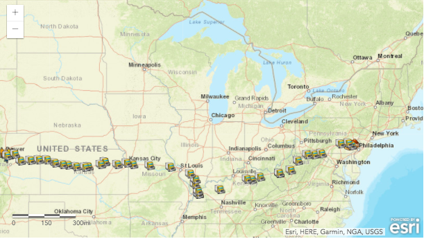
Track David’s End Table Starting Feb. 23!
I don’t leave Philadelphia until about noon Eastern Time on February 23, after I officially close on my house and handed a check. At that time, I am going to start using Esri Collector to collect a point about every hour. Each collected point is symbolized as a truck.
If everything goes according to plan, I will be arriving at SSP’s office on Sunday, February 26. On Monday, many in the office will be coming to assist in unloading the truck’s contents at a local storage facility. David will also get his beautiful end table, which completes its journey.
So….tune in February 23-26, and periodically refresh this blog post to refresh the embedded web map and check the progress. Let us know any curious movement you see with the table!
And if you see me stopped near a good restaurant, please reach out in real time so I can stop there!
Feb. 28 Update
I am very thankful that the trip went per plan. After driving 1,907 miles (yes, I under estimated it), one gains an appreciation of the beauty of America and just how big it is. Going to the Phily airport and flying 4.5 hours just doesn’t offer the same experience. That being said….I hope to never do that again.
On Monday, February 27, approximately 10 coworkers came to assist in unloading the truck. And YES….David got his end table (Figure 7)!


What do you think?