
Included in the many methods for loading electric data into GL’s SynerGEE Electric tool is a comma-separated format called MiddleLink. We wanted to assist utilities with the process of translating their data from GIS to the MiddleLink format to allow for an easy import to SynerGEE.
A challenge presented itself in the idea of allowing a tool like this to be compatible with all types of data models. The tool, as much as possible, uses ArcFM™ model names present in the default electric dataset, but additional model names are used to configure additional optional fields.
The tool itself uses a custom configuration table to determine the GIS objects (down to specific subtypes, if applicable) that correspond to specific MiddleLink object types. If part of this two-part configuration is not specified, the data for that object or model name will be missing from the export, but the export will continue. It’s therefore possible to have a completely customizable export tailored to many possible configurations.
The tool is launched via a command in ArcMap, although the export can also be run using a standalone batch application. The functionality is the same, but the ArcMap command allows for an intuitive selection of feeders:
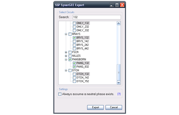
Clicking “Export” will save a MiddleLink CSV file to the location of your choice. It will contain the selected feeder(s), and, if you select the appropriate setting, it will assume that sections will always contain a neutral phase.
The resulting CSV file will be in MiddleLink format, able to easily be imported as a data source in SynerGEE. The tool is completely customizable, so it’s easy to change the types of data if there are any updates to your data model.
The transition from GIS to MiddleLink has its complications, and some tweaks may be needed to fit certain configurations. For example, we’ve noticed that sections that are not split properly at connecting junctions can often appear as unfed in SynerGEE despite having connectivity in GIS. With any tool that accommodates a wide variety of possibilities, data model changes may be required, and the tool can be constantly evolving to fit new possibilities outside of the template we’ve already accounted for. This project makes it easy to export GIS data to the SynerGEE tool. We’ve witnessed this tool become a powerful addition to electric utilities, and we’re always open to suggestions for expanding on this idea. Feel free to learn more or make suggestions by contacting us.

What do you think?