The previous segment of the UN And EAM blog series covered the data modeling and migration strategies that go into building an integrated GIS and EAM system. In this installment, we’ll shift focus to the GIS tools, workflows, and concepts that are pivotal to seamless interaction with an EAM system. These empower users to efficiently create and maintain the data that connects these systems and supports operations across the Utility.
Current Realities Shaping Future Objectives
Enhanced Operational Excellence is a universal aspiration for all Utilities, however attaining that end requires overcoming some common current state challenges. When a Utility takes the initiative to embark on a GIS upgrade and EAM integration program, it often stems from the increasing need to overcome these obstacles. Regardless of the size or type of Utility, many challenges have the same roots and current state scenarios:
Disparate Data, Teams, and Workflows
In many cases today, different departments within Utility have different methods for managing data and executing workflows. These discrepancies impact the ability to consistently model, maintain, and report on these critical assets. Furthermore, there’s an increased need to provide real-time data accessibility across systems, both on-site and remotely.
Modernizing and integrating the GIS and EAM systems serves as a foundational step in unifying teams, workflows, and data needs across the organization.
Data Quality and Maintenance
The adage “clean data is performant data” resonates with GIS professionals everywhere, especially those working at Utilities. While the specific data quality challenges may vary among utilities, every organization contends with some level of data integrity issues within it’s systems.
These data issues are often stem from current state technology and toolsets, including mixed use of Geometric Network or 3rd party tools that result in inconsistent data quality standards. A GIS modernization program presents an excellent opportunity to address these data and technology concerns, leading to a more standardized environment across GIS and the enterprise.
Sunsetting Technology
A lot of foundational technology at Utilities today is approaching end-of-life, or at a minimum are becoming increasingly difficult to upgrade, update, and maintain. It extends from the evolution of ArcGIS Pro and Enterprise to the tools, reporting, and integrations reliant on those legacy systems. Many tools and integrations may lack upgrade paths, prompting organizations to pursue modern, out-of-the-box solutions that offer full support.
GIS and EAM System Alignment
Early establishment and alignment of technology plans for each system are crucial for program success. As these systems will ultimately be interdependent, it’s essential to ensure fundamental alignment across all project aspects, from the selection of systems to the tactical planning of data and integration strategies.
Integrated Asset Strategy
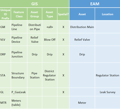
A key initial step is to establish a future state GIS data model and schema that supports Utility Network functionality while also allowing facilitating seamless translation with Asset and Locations in the EAM system. It’s critical for teams to define early on what Features, Fields, Domains that require integration between the systems (see Figure 1).

Supporting the Integration
Another critical consideration for GIS and EAM teams surrounds the finer details for how the systems communicate. This involves meticulous field-level mapping, careful consideration for use of coded domains and descriptions, and configuring the JSON mapping between the systems for syncing. Key areas of importance include:
- REST Service configuration and properly exposing and syncing data.
- Utilizing Automation tools
- Unique ID generation tools and prefixing for Asset creation.
- Attribute Rules and Spatial analysis for field population and relationship creation.
- Establishing triggers for updates between systems (Change Status, Post Date/Time, etc).
- Managing asset lifecycle
- Determining where different assets can be created (GIS vs EAM).
- Leveraging the lifecycle status field across systems to trigger commissioning or retirement.
- Establishing workflows for retiring or abandoning assets while ensuring the accessibility of work history and legacy records as needed.
GIS and EAM Tool Examples
Below are examples of tools that facilitate seamless workflows within an integrated GIS and EAM environment:
Assets and Locations
- Asset and Location Creation – ArcGIS Pro Feature Templates that are preconfigured with the fundamental attribution required for creating UN-compliant GIS features that generate EAM Assets and Locations.
- Customer onboarding – Service facility editing tools equipped with functionality to incorporate new customer and premise information while digitizing features in GIS.
- EAM feature creation – Some non-networked EAM features, for example a Gas Leak, can be plotted automatically in GIS using address or other locational information captured in EAM.
Attribute Automation
- Calculation – Automate calculations on EAM-dependent fields in GIS, such as setting Status, Size and Length, and Date fields based on business logic and other manually entered attributes.
- Constraint – Implement logic to ensure consistent creation of required information in GIS for EAM Assets, such as:
- Limiting differences between length fields (Measured Length vs. Shape Length).
- Requiring and validate Owner information based on location and type of facility.
- Spatial Analysis – Generate data to establish relationships between polygons and underlying assets.
- Synchronization Triggers – Populate a date and time field based on when a new Asset is published to the DEFAULT instance, enabling the EAM system to efficiently identify and import new assets from GIS.


What do you think?